


aygues juntes fait

pidjam
User
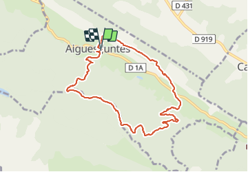

Length
9.3 km

Max alt
566 m

Uphill gradient
348 m
Km-Effort
13.9 km

Min alt
367 m

Downhill gradient
341 m
Boucle
Yes
Creation date :
2021-09-05 06:37:03.664
Updated on :
2021-09-05 09:30:22.953
2h51
Difficulty : Medium

FREE GPS app for hiking
 SityTrail
IGN / Geographical institutes
SityTrail Plus
The world is yours!
About
Trail Walking of 9.3 km to be discovered at Occitania, Ariège, Aigues-Juntes. This trail is proposed by pidjam.
Positioning
Country:
France
Region :
Occitania
Department/Province :
Ariège
Municipality :
Aigues-Juntes
Location:
Unknown
Start:(Dec)
Start:(UTM)
375519 ; 4768101 (31T) N.
Comments