


Matheysiene 2021

starco
User
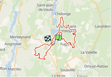

Length
41 km

Max alt
1538 m

Uphill gradient
1436 m
Km-Effort
60 km

Min alt
893 m

Downhill gradient
1441 m
Boucle
No
Creation date :
2021-09-05 05:56:16.0
Updated on :
2021-09-05 10:03:28.155
4h05
Difficulty : Very difficult

FREE GPS app for hiking
 SityTrail
IGN / Geographical institutes
SityTrail Plus
The world is yours!
About
Trail Mountain bike of 41 km to be discovered at Auvergne-Rhône-Alpes, Isère, Pierre-Châtel. This trail is proposed by starco.
Description
41kme
Positioning
Country:
France
Region :
Auvergne-Rhône-Alpes
Department/Province :
Isère
Municipality :
Pierre-Châtel
Location:
Unknown
Start:(Dec)
Start:(UTM)
719137 ; 4981593 (31T) N.
Comments