


font d alagnon le lioran

aupi
User
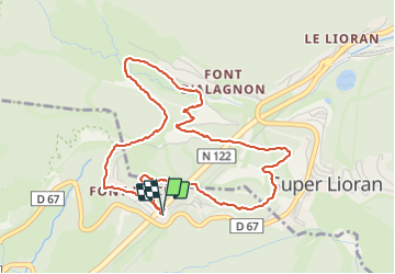

Length
5.3 km

Max alt
1361 m

Uphill gradient
173 m
Km-Effort
7.6 km

Min alt
1198 m

Downhill gradient
178 m
Boucle
Yes
Creation date :
2021-09-06 11:58:13.188
Updated on :
2021-09-06 15:20:54.773
3h21
Difficulty : Medium

FREE GPS app for hiking
 SityTrail
IGN / Geographical institutes
SityTrail Plus
The world is yours!
About
Trail Walking of 5.3 km to be discovered at Auvergne-Rhône-Alpes, Cantal, Saint-Jacques-des-Blats. This trail is proposed by aupi.
Positioning
Country:
France
Region :
Auvergne-Rhône-Alpes
Department/Province :
Cantal
Municipality :
Saint-Jacques-des-Blats
Location:
Unknown
Start:(Dec)
Start:(UTM)
479248 ; 4992037 (31T) N.
Comments