


chaumiène astet

Evelyne et Francois
User

Length
16.8 km

Max alt
1424 m

Uphill gradient
875 m
Km-Effort
28 km

Min alt
648 m

Downhill gradient
876 m
Boucle
Yes
Creation date :
2021-09-07 19:46:14.738
Updated on :
2021-09-07 19:46:17.038
6h28
Difficulty : Very difficult

FREE GPS app for hiking
 SityTrail
IGN / Geographical institutes
SityTrail Plus
The world is yours!
About
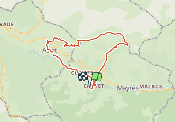
Trail Walking of 16.8 km to be discovered at Auvergne-Rhône-Alpes, Ardèche, Mayres. This trail is proposed by Evelyne et Francois.
Description
belle boucle sur les crêtes de chaumiène et plongeon dans le vallon d'Astet. descente en suivant l'Ardèche
de torrents en baignoires.
Positioning
Country:
France
Region :
Auvergne-Rhône-Alpes
Department/Province :
Ardèche
Municipality :
Mayres
Location:
Unknown
Start:(Dec)
Start:(UTM)
586206 ; 4946460 (31T) N.
Comments