


trouzilit aberwrach

RoMo
User
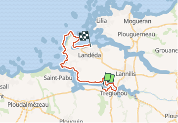

Length
22 km

Max alt
45 m

Uphill gradient
255 m
Km-Effort
26 km

Min alt
-3 m

Downhill gradient
263 m
Boucle
No
Creation date :
2021-09-07 06:41:48.742
Updated on :
2021-09-08 13:44:40.84
6h06
Difficulty : Medium

FREE GPS app for hiking
 SityTrail
IGN / Geographical institutes
SityTrail Plus
The world is yours!
About
Trail Walking of 22 km to be discovered at Brittany, Finistère, Tréglonou. This trail is proposed by RoMo.
Description
randonnee entre aber benoit et wrach plus bordure de mer ste marguerite
Photos


Positioning
Country:
France
Region :
Brittany
Department/Province :
Finistère
Municipality :
Tréglonou
Location:
Unknown
Start:(Dec)
Start:(UTM)
385331 ; 5379210 (30U) N.
Comments