


Randonnée Montdardier saint maurice navacelle

jib971
User
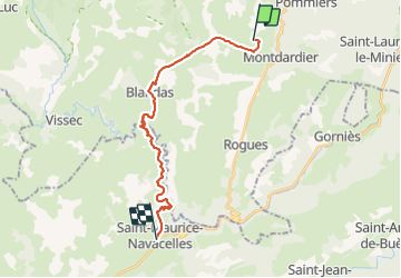

Length
23 km

Max alt
665 m

Uphill gradient
633 m
Km-Effort
32 km

Min alt
264 m

Downhill gradient
650 m
Boucle
No
Creation date :
2021-09-10 06:30:24.0
Updated on :
2021-09-10 15:44:28.382
9h13
Difficulty : Difficult

FREE GPS app for hiking
 SityTrail
IGN / Geographical institutes
SityTrail Plus
The world is yours!
About
Trail Walking of 23 km to be discovered at Occitania, Gard, Montdardier. This trail is proposed by jib971.
Positioning
Country:
France
Region :
Occitania
Department/Province :
Gard
Municipality :
Montdardier
Location:
Unknown
Start:(Dec)
Start:(UTM)
546314 ; 4864820 (31T) N.
Comments