


abraham par Cautet

Evelyne et Francois
User
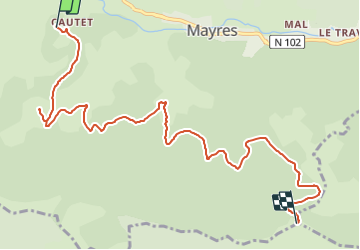

Length
9.6 km

Max alt
1471 m

Uphill gradient
891 m
Km-Effort
19 km

Min alt
705 m

Downhill gradient
131 m
Boucle
No
Creation date :
2021-09-10 18:40:03.92
Updated on :
2021-09-10 18:40:05.946
4h18
Difficulty : Difficult

FREE GPS app for hiking
 SityTrail
IGN / Geographical institutes
SityTrail Plus
The world is yours!
About
Trail Walking of 9.6 km to be discovered at Auvergne-Rhône-Alpes, Ardèche, Mayres. This trail is proposed by Evelyne et Francois.
Positioning
Country:
France
Region :
Auvergne-Rhône-Alpes
Department/Province :
Ardèche
Municipality :
Mayres
Location:
Unknown
Start:(Dec)
Start:(UTM)
586205 ; 4946460 (31T) N.
Comments