


abraham par col de la croix de bauzon

Evelyne et Francois
User
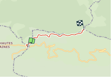

Length
3.5 km

Max alt
1471 m

Uphill gradient
231 m
Km-Effort
6 km

Min alt
1306 m

Downhill gradient
71 m
Boucle
No
Creation date :
2021-09-10 18:48:46.05
Updated on :
2021-09-10 18:48:47.65
1h22
Difficulty : Medium

FREE GPS app for hiking
 SityTrail
IGN / Geographical institutes
SityTrail Plus
The world is yours!
About
Trail Walking of 3.5 km to be discovered at Auvergne-Rhône-Alpes, Ardèche, Mayres. This trail is proposed by Evelyne et Francois.
Positioning
Country:
France
Region :
Auvergne-Rhône-Alpes
Department/Province :
Ardèche
Municipality :
Mayres
Location:
Unknown
Start:(Dec)
Start:(UTM)
587029 ; 4942999 (31T) N.
Comments