


estaing G3 fait

LouisROGER
User GUIDE
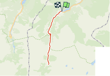

Length
13.3 km

Max alt
1681 m

Uphill gradient
567 m
Km-Effort
21 km

Min alt
1161 m

Downhill gradient
564 m
Boucle
Yes
Creation date :
2021-09-10 07:17:27.788
Updated on :
2021-09-12 08:24:56.654
6h06
Difficulty : Very difficult

FREE GPS app for hiking
 SityTrail
IGN / Geographical institutes
SityTrail Plus
The world is yours!
About
Trail Walking of 13.3 km to be discovered at Occitania, Hautespyrenees, Estaing. This trail is proposed by LouisROGER.
Positioning
Country:
France
Region :
Occitania
Department/Province :
Hautespyrenees
Municipality :
Estaing
Location:
Unknown
Start:(Dec)
Start:(UTM)
727499 ; 4754076 (30T) N.
Comments