


sortie vtt 12092021 antenne

fabwin
User GUIDE
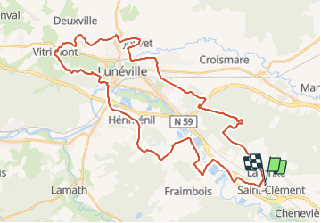

Length
45 km

Max alt
324 m

Uphill gradient
403 m
Km-Effort
50 km

Min alt
219 m

Downhill gradient
400 m
Boucle
Yes
Creation date :
2021-09-12 06:46:35.301
Updated on :
2021-09-12 10:02:39.023
2h37
Difficulty : Medium

FREE GPS app for hiking
 SityTrail
IGN / Geographical institutes
SityTrail Plus
The world is yours!
About
Trail Mountain bike of 45 km to be discovered at Grand Est, Meurthe-et-Moselle, Saint-Clément. This trail is proposed by fabwin.
Positioning
Country:
France
Region :
Grand Est
Department/Province :
Meurthe-et-Moselle
Municipality :
Saint-Clément
Location:
Unknown
Start:(Dec)
Start:(UTM)
322969 ; 5378342 (32U) N.
Comments