


Route de la Galeuse

Romain Boubou
User
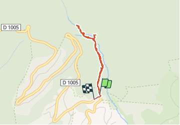

Length
3.1 km

Max alt
867 m

Uphill gradient
106 m
Km-Effort
4.5 km

Min alt
750 m

Downhill gradient
109 m
Boucle
Yes
Creation date :
2021-09-12 09:13:17.0
Updated on :
2021-09-12 10:31:54.743
1h18
Difficulty : Easy

FREE GPS app for hiking
 SityTrail
IGN / Geographical institutes
SityTrail Plus
The world is yours!
About
Trail Walking of 3.1 km to be discovered at Auvergne-Rhône-Alpes, Ain, Gex. This trail is proposed by Romain Boubou.
Positioning
Country:
France
Region :
Auvergne-Rhône-Alpes
Department/Province :
Ain
Municipality :
Gex
Location:
Unknown
Start:(Dec)
Start:(UTM)
273626 ; 5137334 (32T) N.
Comments