


les moulins melisey

PatriceCocuaud
User
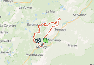

Length
23 km

Max alt
500 m

Uphill gradient
455 m
Km-Effort
29 km

Min alt
327 m

Downhill gradient
454 m
Boucle
Yes
Creation date :
2021-09-12 08:30:44.963
Updated on :
2021-09-12 11:13:57.627
2h42
Difficulty : Medium

FREE GPS app for hiking
 SityTrail
IGN / Geographical institutes
SityTrail Plus
The world is yours!
About
Trail Mountain bike of 23 km to be discovered at Bourgogne-Franche-Comté, Haute-Saône, Mélisey. This trail is proposed by PatriceCocuaud.
Positioning
Country:
France
Region :
Bourgogne-Franche-Comté
Department/Province :
Haute-Saône
Municipality :
Mélisey
Location:
Unknown
Start:(Dec)
Start:(UTM)
318768 ; 5291825 (32T) N.
Comments