


Passerelles Monteynard

ETMU5496
User

Length
15.6 km

Max alt
692 m

Uphill gradient
552 m
Km-Effort
23 km

Min alt
470 m

Downhill gradient
544 m
Boucle
No
Creation date :
2021-09-12 08:55:28.0
Updated on :
2021-09-12 14:04:33.638
3h49
Difficulty : Medium

FREE GPS app for hiking
 SityTrail
IGN / Geographical institutes
SityTrail Plus
The world is yours!
About
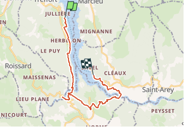
Trail Walking of 15.6 km to be discovered at Auvergne-Rhône-Alpes, Isère, Treffort. This trail is proposed by ETMU5496.
Photos


Positioning
Country:
France
Region :
Auvergne-Rhône-Alpes
Department/Province :
Isère
Municipality :
Treffort
Location:
Unknown
Start:(Dec)
Start:(UTM)
710921 ; 4976089 (31T) N.
Comments