


Les Plaines Saint-Jeannet

Clo0413
User
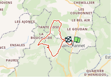

Length
14.2 km

Max alt
891 m

Uphill gradient
470 m
Km-Effort
20 km

Min alt
582 m

Downhill gradient
470 m
Boucle
Yes
Creation date :
2021-09-12 08:05:58.785
Updated on :
2021-09-12 15:49:37.872
4h10
Difficulty : Easy

FREE GPS app for hiking
 SityTrail
IGN / Geographical institutes
SityTrail Plus
The world is yours!
About
Trail Walking of 14.2 km to be discovered at Provence-Alpes-Côte d'Azur, Alpes-de-Haute-Provence, Saint-Jeannet. This trail is proposed by Clo0413.
Positioning
Country:
France
Region :
Provence-Alpes-Côte d'Azur
Department/Province :
Alpes-de-Haute-Provence
Municipality :
Saint-Jeannet
Location:
Unknown
Start:(Dec)
Start:(UTM)
269259 ; 4870460 (32T) N.
Comments