


Aiglepierre 20210913

cmike39
User
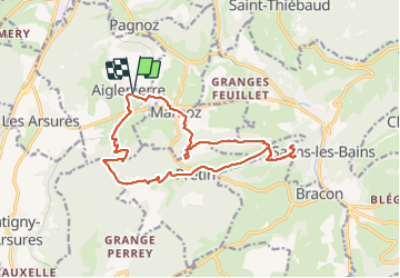

Length
17.1 km

Max alt
612 m

Uphill gradient
677 m
Km-Effort
26 km

Min alt
318 m

Downhill gradient
676 m
Boucle
Yes
Creation date :
2021-09-12 09:10:25.078
Updated on :
2021-09-12 14:42:56.951
5h28
Difficulty : Very difficult

FREE GPS app for hiking
 SityTrail
IGN / Geographical institutes
SityTrail Plus
The world is yours!
About
Trail Walking of 17.1 km to be discovered at Bourgogne-Franche-Comté, Jura, Aiglepierre. This trail is proposed by cmike39.
Positioning
Country:
France
Region :
Bourgogne-Franche-Comté
Department/Province :
Jura
Municipality :
Aiglepierre
Location:
Unknown
Start:(Dec)
Start:(UTM)
714586 ; 5203786 (31T) N.
Comments