


st Marcel en Dombes 12.9 2021

maclobar
User
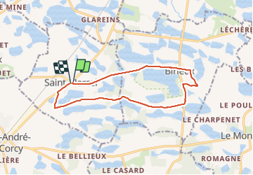

Length
13.7 km

Max alt
296 m

Uphill gradient
83 m
Km-Effort
14.8 km

Min alt
277 m

Downhill gradient
84 m
Boucle
Yes
Creation date :
2021-09-12 08:30:24.741
Updated on :
2021-09-12 15:00:19.275
3h00
Difficulty : Difficult

FREE GPS app for hiking
 SityTrail
IGN / Geographical institutes
SityTrail Plus
The world is yours!
About
Trail Walking of 13.7 km to be discovered at Auvergne-Rhône-Alpes, Ain, Saint-Marcel. This trail is proposed by maclobar.
Description
belle rando en campagne parmi les étangs
Positioning
Country:
France
Region :
Auvergne-Rhône-Alpes
Department/Province :
Ain
Municipality :
Saint-Marcel
Location:
Unknown
Start:(Dec)
Start:(UTM)
654011 ; 5090289 (31T) N.
Comments