


dung

Evelyne3
User
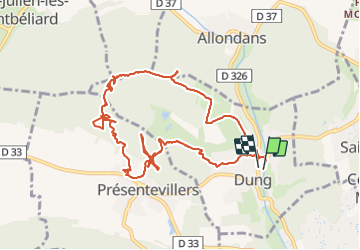

Length
11.5 km

Max alt
436 m

Uphill gradient
327 m
Km-Effort
15.8 km

Min alt
321 m

Downhill gradient
318 m
Boucle
Yes
Creation date :
2021-09-13 11:57:49.005
Updated on :
2021-09-13 15:43:39.846
2h24
Difficulty : Difficult

FREE GPS app for hiking
 SityTrail
IGN / Geographical institutes
SityTrail Plus
The world is yours!
About
Trail Walking of 11.5 km to be discovered at Bourgogne-Franche-Comté, Doubs, Dung. This trail is proposed by Evelyne3.
Description
Parking de la mairie monument aux morts
Photos


Positioning
Country:
France
Region :
Bourgogne-Franche-Comté
Department/Province :
Doubs
Municipality :
Dung
Location:
Unknown
Start:(Dec)
Start:(UTM)
330754 ; 5263571 (32T) N.
Comments