


Autechaux via Thulay,Glay,Blamont depuis Mandeure

tiene
User
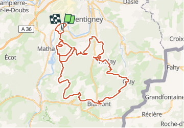

Length
48 km

Max alt
596 m

Uphill gradient
1115 m
Km-Effort
63 km

Min alt
328 m

Downhill gradient
1115 m
Boucle
Yes
Creation date :
2021-09-13 12:17:05.236
Updated on :
2021-09-15 14:36:47.626
3h49
Difficulty : Difficult

FREE GPS app for hiking
 SityTrail
IGN / Geographical institutes
SityTrail Plus
The world is yours!
About
Trail Mountain bike of 48 km to be discovered at Bourgogne-Franche-Comté, Doubs, Mandeure. This trail is proposed by tiene.
Positioning
Country:
France
Region :
Bourgogne-Franche-Comté
Department/Province :
Doubs
Municipality :
Mandeure
Location:
Unknown
Start:(Dec)
Start:(UTM)
334311 ; 5257738 (32T) N.
Comments