


69 vaugneray réelle

trietsch
User

Length
10.8 km

Max alt
787 m

Uphill gradient
415 m
Km-Effort
16.3 km

Min alt
394 m

Downhill gradient
418 m
Boucle
Yes
Creation date :
2021-09-14 08:14:56.0
Updated on :
2021-09-14 12:07:18.407
2h57
Difficulty : Difficult

FREE GPS app for hiking
 SityTrail
IGN / Geographical institutes
SityTrail Plus
The world is yours!
About
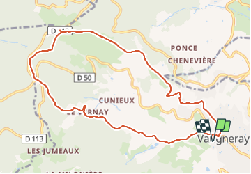
Trail Walking of 10.8 km to be discovered at Auvergne-Rhône-Alpes, Rhône, Vaugneray. This trail is proposed by trietsch.
Positioning
Country:
France
Region :
Auvergne-Rhône-Alpes
Department/Province :
Rhône
Municipality :
Vaugneray
Location:
Vaugneray
Start:(Dec)
Start:(UTM)
628787 ; 5066190 (31T) N.
Comments