


Rabieu Croix du Gibret

leboucherdaniel
User
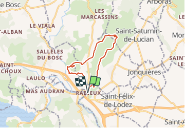

Length
12 km

Max alt
273 m

Uphill gradient
302 m
Km-Effort
16.1 km

Min alt
74 m

Downhill gradient
302 m
Boucle
Yes
Creation date :
2021-09-14 22:03:29.519
Updated on :
2021-09-14 22:04:28.303
3h39
Difficulty : Easy

FREE GPS app for hiking
 SityTrail
IGN / Geographical institutes
SityTrail Plus
The world is yours!
About
Trail On foot of 12 km to be discovered at Occitania, Hérault, Ceyras. This trail is proposed by leboucherdaniel.
Positioning
Country:
France
Region :
Occitania
Department/Province :
Hérault
Municipality :
Ceyras
Location:
Unknown
Start:(Dec)
Start:(UTM)
535312 ; 4834899 (31T) N.
Comments