


2021-09-15_11h03m04_la-velomaritime-eurovelo-4-bis-mont-saint-michel-le-vivier-sur-mer

FOUCAULT
User
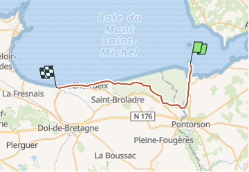

Length
29 km

Max alt
14 m

Uphill gradient
99 m
Km-Effort
30 km

Min alt
0 m

Downhill gradient
98 m
Boucle
No
Creation date :
2021-09-15 09:03:04.232
Updated on :
2021-09-15 09:03:14.446

FREE GPS app for hiking
 SityTrail
IGN / Geographical institutes
SityTrail Plus
The world is yours!
About
Trail of 29 km to be discovered at Normandy, Manche, Pontorson. This trail is proposed by FOUCAULT.
Positioning
Country:
France
Region :
Normandy
Department/Province :
Manche
Municipality :
Pontorson
Location:
Pontorson
Start:(Dec)
Start:(UTM)
609731 ; 5387938 (30U) N.
Comments