


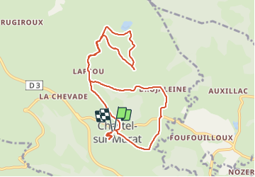
Tourbières Chastel sur Murat

pb07
User

Length
10.3 km

Max alt
1240 m

Uphill gradient
318 m
Km-Effort
14.5 km

Min alt
1068 m

Downhill gradient
313 m
Boucle
Yes
Creation date :
2021-09-15 08:58:16.521
Updated on :
2021-09-15 13:50:40.835
4h51
Difficulty : Difficult

FREE GPS app for hiking
 SityTrail
IGN / Geographical institutes
SityTrail Plus
The world is yours!
About
Trail Walking of 10.3 km to be discovered at Auvergne-Rhône-Alpes, Cantal, Murat. This trail is proposed by pb07.
Positioning
Country:
France
Region :
Auvergne-Rhône-Alpes
Department/Province :
Cantal
Municipality :
Murat
Location:
Chastel-sur-Murat
Start:(Dec)
Start:(UTM)
488720 ; 4996836 (31T) N.
Comments