


Col Pailheres - Etang Bleu, Etang Noir

patbt
User
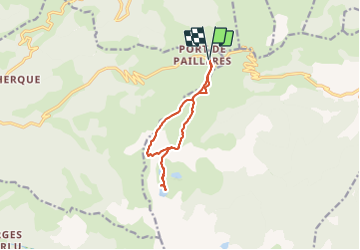

Length
11.2 km

Max alt
2310 m

Uphill gradient
649 m
Km-Effort
19.9 km

Min alt
1927 m

Downhill gradient
647 m
Boucle
Yes
Creation date :
2021-09-13 08:59:18.664
Updated on :
2021-09-15 15:21:49.018
5h26
Difficulty : Medium

FREE GPS app for hiking
 SityTrail
IGN / Geographical institutes
SityTrail Plus
The world is yours!
About
Trail Walking of 11.2 km to be discovered at Occitania, Ariège, Ascou. This trail is proposed by patbt.
Positioning
Country:
France
Region :
Occitania
Department/Province :
Ariège
Municipality :
Ascou
Location:
Unknown
Start:(Dec)
Start:(UTM)
417120 ; 4731662 (31T) N.
Comments