


Val d'Orlu - Etang d'en Beys

patbt
User
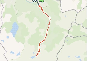

Length
16.5 km

Max alt
1995 m

Uphill gradient
885 m
Km-Effort
28 km

Min alt
1139 m

Downhill gradient
883 m
Boucle
Yes
Creation date :
2021-09-14 08:28:31.026
Updated on :
2021-09-15 15:21:52.192
6h29
Difficulty : Medium

FREE GPS app for hiking
 SityTrail
IGN / Geographical institutes
SityTrail Plus
The world is yours!
About
Trail Walking of 16.5 km to be discovered at Occitania, Ariège, Orlu. This trail is proposed by patbt.
Positioning
Country:
France
Region :
Occitania
Department/Province :
Ariège
Municipality :
Orlu
Location:
Unknown
Start:(Dec)
Start:(UTM)
413927 ; 4725680 (31T) N.
Comments