


Rocher de Laqueuille

pb07
User
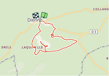

Length
8.6 km

Max alt
1282 m

Uphill gradient
270 m
Km-Effort
12.2 km

Min alt
1047 m

Downhill gradient
271 m
Boucle
Yes
Creation date :
2021-09-16 07:21:04.041
Updated on :
2021-09-16 10:13:43.759
2h51
Difficulty : Difficult

FREE GPS app for hiking
 SityTrail
IGN / Geographical institutes
SityTrail Plus
The world is yours!
About
Trail Walking of 8.6 km to be discovered at Auvergne-Rhône-Alpes, Cantal, Dienne. This trail is proposed by pb07.
Positioning
Country:
France
Region :
Auvergne-Rhône-Alpes
Department/Province :
Cantal
Municipality :
Dienne
Location:
Unknown
Start:(Dec)
Start:(UTM)
483480 ; 5000496 (31T) N.
Comments