


Refuge des Bessines - Pïc Carlit - Refuge des Bouillouses

ARVIEU
User
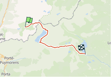

Length
19.4 km

Max alt
2885 m

Uphill gradient
1221 m
Km-Effort
36 km

Min alt
2003 m

Downhill gradient
1299 m
Boucle
No
Creation date :
2021-09-17 20:22:14.914
Updated on :
2021-09-17 20:23:00.793
8h10
Difficulty : Very difficult

FREE GPS app for hiking
 SityTrail
IGN / Geographical institutes
SityTrail Plus
The world is yours!
About
Trail Walking of 19.4 km to be discovered at Occitania, Ariège, Mérens-les-Vals. This trail is proposed by ARVIEU.
Positioning
Country:
France
Region :
Occitania
Department/Province :
Ariège
Municipality :
Mérens-les-Vals
Location:
Unknown
Start:(Dec)
Start:(UTM)
407241 ; 4717414 (31T) N.
Comments