


Golinhac / Conques

DENNEBECQ
User
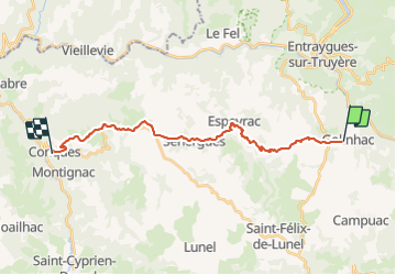

Length
21 km

Max alt
675 m

Uphill gradient
430 m
Km-Effort
28 km

Min alt
294 m

Downhill gradient
805 m
Boucle
No
Creation date :
2021-09-18 06:04:13.234
Updated on :
2021-09-18 12:07:38.889
5h43
Difficulty : Medium

FREE GPS app for hiking
 SityTrail
IGN / Geographical institutes
SityTrail Plus
The world is yours!
About
Trail Walking of 21 km to be discovered at Occitania, Aveyron, Golinhac. This trail is proposed by DENNEBECQ.
Positioning
Country:
France
Region :
Occitania
Department/Province :
Aveyron
Municipality :
Golinhac
Location:
Unknown
Start:(Dec)
Start:(UTM)
466605 ; 4939073 (31T) N.
Comments