


lacet des Clots (pt1290) - lac des Vallons - G3

rolland-a
User
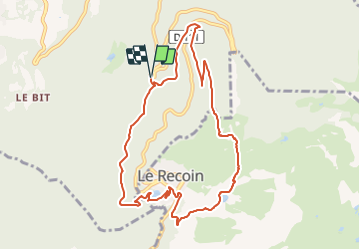

Length
9.9 km

Max alt
1837 m

Uphill gradient
569 m
Km-Effort
17.5 km

Min alt
1297 m

Downhill gradient
569 m
Boucle
Yes
Creation date :
2021-09-18 13:33:38.668
Updated on :
2021-09-18 14:58:24.233
3h58
Difficulty : Difficult

FREE GPS app for hiking
 SityTrail
IGN / Geographical institutes
SityTrail Plus
The world is yours!
About
Trail Walking of 9.9 km to be discovered at Auvergne-Rhône-Alpes, Isère, Saint-Martin-d'Uriage. This trail is proposed by rolland-a.
Positioning
Country:
France
Region :
Auvergne-Rhône-Alpes
Department/Province :
Isère
Municipality :
Saint-Martin-d'Uriage
Location:
Unknown
Start:(Dec)
Start:(UTM)
725949 ; 5002309 (31T) N.
Comments