


jogging 20/9/21

PatriceCocuaud
User
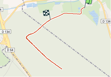

Length
4.1 km

Max alt
326 m

Uphill gradient
54 m
Km-Effort
4.8 km

Min alt
299 m

Downhill gradient
41 m
Boucle
No
Creation date :
2021-09-20 09:02:01.135
Updated on :
2021-09-20 09:50:56.51
30m
Difficulty : Very easy

FREE GPS app for hiking
 SityTrail
IGN / Geographical institutes
SityTrail Plus
The world is yours!
About
Trail Running of 4.1 km to be discovered at Bourgogne-Franche-Comté, Haute-Saône, Franchevelle. This trail is proposed by PatriceCocuaud.
Positioning
Country:
France
Region :
Bourgogne-Franche-Comté
Department/Province :
Haute-Saône
Municipality :
Franchevelle
Location:
Unknown
Start:(Dec)
Start:(UTM)
309557 ; 5290278 (32T) N.
Comments