


clamart

verozerr
User
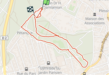

Length
2.9 km

Max alt
172 m

Uphill gradient
40 m
Km-Effort
3.4 km

Min alt
153 m

Downhill gradient
30 m
Boucle
Yes
Creation date :
2021-09-20 13:08:52.254
Updated on :
2021-09-20 14:26:15.674
1h12
Difficulty : Easy

FREE GPS app for hiking
 SityTrail
IGN / Geographical institutes
SityTrail Plus
The world is yours!
About
Trail Walking of 2.9 km to be discovered at Ile-de-France, Hauts-de-Seine, Clamart. This trail is proposed by verozerr.
Positioning
Country:
France
Region :
Ile-de-France
Department/Province :
Hauts-de-Seine
Municipality :
Clamart
Location:
Unknown
Start:(Dec)
Start:(UTM)
445496 ; 5405266 (31U) N.
Comments