


Étang des nénufars

francoisecarlier
User
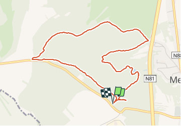

Length
5.2 km

Max alt
383 m

Uphill gradient
108 m
Km-Effort
6.6 km

Min alt
309 m

Downhill gradient
109 m
Boucle
Yes
Creation date :
2021-09-20 15:15:05.0
Updated on :
2021-09-20 16:27:52.643
1h12
Difficulty : Very easy

FREE GPS app for hiking
 SityTrail
IGN / Geographical institutes
SityTrail Plus
The world is yours!
About
Trail Walking of 5.2 km to be discovered at Wallonia, Luxembourg, Messancy. This trail is proposed by francoisecarlier.
Positioning
Country:
Belgium
Region :
Wallonia
Department/Province :
Luxembourg
Municipality :
Messancy
Location:
Unknown
Start:(Dec)
Start:(UTM)
702448 ; 5497083 (31U) N.
Comments