Trail Walking Corbigny - Compostelle étape 3  - Photo
 maginot
maginot

User

© OpenStreetMap contributors
Length
Length
32 km
Max alt
Max alt
348 m
Uphill gradient
Uphill gradient
491 m
Km-Effort
Km-Effort  
38 km
Min alt
Min alt
188 m
Downhill gradient
Downhill gradient
424 m
Boucle
Boucle
No
Creation date :
2021-09-22 06:57:51.0
Updated on :
2021-09-22 16:42:50.658

(0 Reviews)

Walking
Walking
8h00
Difficulty : Difficult

Scan this QR Code to open this trail in the SityTrail application

FREE GPS app for hiking

Logo SityTrail SityTrail

IGN / Geographical institutes

Download SityTrail from the App Store Download SityTrail from Google Play

Logo SityTrail SityTrail World

The world is yours!

Download SityTrail from the App Store Download SityTrail from Google Play Download SityTrail on Huawei AppGallery

About

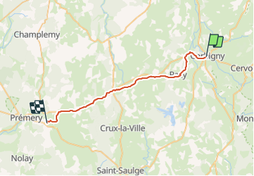
Trail Walking of 32 km to be discovered at Bourgogne-Franche-Comté, Nièvre, Corbigny. This trail is proposed by maginot.

Description

Départ de Corbigny à 8h30
Pour Pemery
Début parcours,maintenant sur la fin beaucoup de route Dangereux et pas agréable

Elevation profile

Positioning

Country:
France
Region :
Bourgogne-Franche-Comté
Department/Province :
Nièvre
Municipality :
Corbigny
Location:
Unknown
Start:(UTM)
551622 ; 5233882 (31T) N.

Trails nearby

Trail 4x4 Chitry-les-Mines - Dimanche - Photo
4x4
eldingue

4x4

Chitry-les-Mines, Bourgogne-Franche-Comté, Nièvre, France
167 km | 198 km-effort
9h 10min
No
Trail Bicycle tourism Chaumot - TB 9  Chaumot - Clamecy - Photo
Bicycle tourism
famiski

Bicycle tourism

Difficult
Chaumot, Bourgogne-Franche-Comté, Nièvre, France
33 km | 38 km-effort
2h 6min
No
Trail Walking Corbigny - Corbigny - Photo
Walking
Tournan

Walking

Difficult
Corbigny, Bourgogne-Franche-Comté, Nièvre, France
10.7 km | 13.3 km-effort
3h 1min
Yes
Trail Road bike Chaumot - 03 corbigy decize - Photo
Road bike
berhin

Road bike

Very difficult
Chaumot, Bourgogne-Franche-Comté, Nièvre, France
90 km | 98 km-effort
12h 47min
No


Close
My subscriptions