


Rando du 24/09

dudu79
User
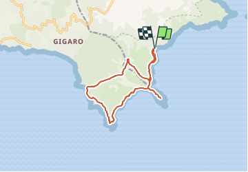

Length
13.6 km

Max alt
114 m

Uphill gradient
370 m
Km-Effort
18.6 km

Min alt
0 m

Downhill gradient
371 m
Boucle
Yes
Creation date :
2021-09-23 07:59:56.44
Updated on :
2021-09-23 07:59:57.687
4h13
Difficulty : Medium

FREE GPS app for hiking
 SityTrail
IGN / Geographical institutes
SityTrail Plus
The world is yours!
About
Trail Walking of 13.6 km to be discovered at Provence-Alpes-Côte d'Azur, Var, Ramatuelle. This trail is proposed by dudu79.
Description
A.R au départ de la plage de l'Escalet (Ramatuelle)
Positioning
Country:
France
Region :
Provence-Alpes-Côte d'Azur
Department/Province :
Var
Municipality :
Ramatuelle
Location:
Unknown
Start:(Dec)
Start:(UTM)
308428 ; 4784324 (32T) N.
Comments