![](/images/other/stat-length.png)
![Trail Walking Prémery - Compostelle etape 4 - Photo](https://media.geolcdn.com/t/1900/400/ext.pjpeg?maxdim=2&url=https%3A%2F%2Fstatic1.geolcdn.com%2Fsiteimages%2Fupload%2Ffiles%2F1553511878bg_sport_marche.png)
Compostelle etape 4
maginot
User
![Length](/images/other/stat-length.png)
Length
25 km
![Max alt](https://static1.geolcdn.com/siteimages/upload/files/1508320355ic_sort_altitude_max_24dp.png)
Max alt
321 m
![Uphill gradient](https://static1.geolcdn.com/siteimages/upload/files/1508320355ic_sort_den_pos_24dp.png)
Uphill gradient
269 m
![Km-Effort](/images/other/stat-length.png)
Km-Effort
29 km
![Min alt](https://static1.geolcdn.com/siteimages/upload/files/1508320355ic_sort_altitude_min_24dp.png)
Min alt
193 m
![Downhill gradient](https://static1.geolcdn.com/siteimages/upload/files/1508320355ic_sort_den_neg_24dp.png)
Downhill gradient
331 m
![Boucle](https://static1.geolcdn.com/siteimages/upload/files/16400158638029165_repeat_loop_refresh_sync_direction_icon.png)
Boucle
No
Creation date :
2021-09-23 06:03:59.0
Updated on :
2021-09-23 17:51:04.372
![Walking](https://static1.geolcdn.com/sitytour/trail-icons/101.png)
8h40
Difficulty : Medium
![Scan this QR Code to open this trail in the SityTrail application](https://capi.geolives.com/qq0zvz2zws4bq2lad0pu/sitytour/trails/2947242/qr.png?size=200)
FREE GPS app for hiking
About
Trail Walking of 25 km to be discovered at Bourgogne-Franche-Comté, Nièvre, Prémery. This trail is proposed by maginot.
Description
Départ 8h de Breuil maison donativo tenue par Chantal je conseil personne formidable repas excellent et calme super dortoir
Encore beaucoup de petite route peu de chemin mais campagne très jolie surtout le matin avec le brouillard sur les plaines
Arrive à Guerigny
Positioning
Country:
France
Region :
Bourgogne-Franche-Comté
Department/Province :
Nièvre
Municipality :
Prémery
Location:
Unknown
Start:(Dec)
Start:(UTM)
528292 ; 5223959 (31T) N.
Comments
Trails nearby
![Trail Walking Lurcy-le-Bourg - Prémery. Nevers - Photo](https://media.geolcdn.com/t/375/260/ext.jpg?maxdim=2&url=https%3A%2F%2Fstatic1.geolcdn.com%2Fsiteimages%2Fupload%2Ffiles%2F1553511878bg_sport_marche.png)
![Walking Walking](https://static1.geolcdn.com/sitytour/trail-icons/101.png)
Prémery. Nevers
Walking
Difficult
Lurcy-le-Bourg,
Bourgogne-Franche-Comté,
Nièvre,
France
![](/images/other/stat-length.png)
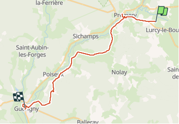
38 km | 43 km-effort
7h 23min
![](https://static1.geolcdn.com/siteimages/upload/files/16400158638029165_repeat_loop_refresh_sync_direction_icon.png)
No