


Piton des neiges

togolo28
User
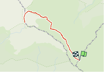

Length
6.8 km

Max alt
3057 m

Uphill gradient
577 m
Km-Effort
14.5 km

Min alt
2472 m

Downhill gradient
576 m
Boucle
Yes
Creation date :
2021-09-23 23:51:30.953
Updated on :
2021-10-16 09:30:34.13
3h22
Difficulty : Difficult

FREE GPS app for hiking
 SityTrail
IGN / Geographical institutes
SityTrail Plus
The world is yours!
About
Trail Walking of 6.8 km to be discovered at Réunion, Unknown, Saint-Benoît. This trail is proposed by togolo28.
Positioning
Country:
France
Region :
Réunion
Department/Province :
Unknown
Municipality :
Saint-Benoît
Location:
Unknown
Start:(Dec)
Start:(UTM)
343822 ; 7664966 (40K) S.
Comments