


Randonnée du 24/09/2021 à 18:18

houbart
User
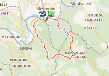

Length
15.3 km

Max alt
307 m

Uphill gradient
436 m
Km-Effort
21 km

Min alt
100 m

Downhill gradient
427 m
Boucle
Yes
Creation date :
2021-09-25 07:15:16.9
Updated on :
2021-10-05 16:29:37.889
4h42
Difficulty : Medium

FREE GPS app for hiking
 SityTrail
IGN / Geographical institutes
SityTrail Plus
The world is yours!
About
Trail On foot of 15.3 km to be discovered at Occitania, Lot, Meyronne. This trail is proposed by houbart.
Positioning
Country:
France
Region :
Occitania
Department/Province :
Lot
Municipality :
Meyronne
Location:
Unknown
Start:(Dec)
Start:(UTM)
387830 ; 4969147 (31T) N.
Comments