


vianden . bivels . vianden

stef789
User GUIDE
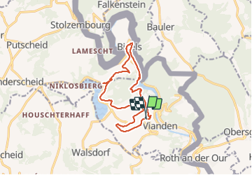

Length
12.8 km

Max alt
494 m

Uphill gradient
456 m
Km-Effort
19 km

Min alt
222 m

Downhill gradient
485 m
Boucle
Yes
Creation date :
2021-09-25 12:13:11.902
Updated on :
2021-09-25 16:54:51.559
4h40
Difficulty : Medium

FREE GPS app for hiking
 SityTrail
IGN / Geographical institutes
SityTrail Plus
The world is yours!
About
Trail Walking of 12.8 km to be discovered at Unknown, Canton Vianden, Vianden. This trail is proposed by stef789.
Photos


22 photos in total. Please click on a photo to see them all in the gallery.
Positioning
Country:
Luxembourg
Region :
Unknown
Department/Province :
Canton Vianden
Municipality :
Vianden
Location:
Unknown
Start:(Dec)
Start:(UTM)
299027 ; 5535256 (32U) N.
Comments