


RIF-09-01 du 25,09,2021

bene_dictus77
User

Length
21 km

Max alt
170 m

Uphill gradient
237 m
Km-Effort
24 km

Min alt
115 m

Downhill gradient
273 m
Boucle
No
Creation date :
2021-09-25 07:45:48.646
Updated on :
2021-09-25 17:09:32.913
6h26
Difficulty : Very easy

FREE GPS app for hiking
 SityTrail
IGN / Geographical institutes
SityTrail Plus
The world is yours!
About
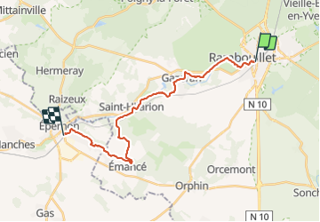
Trail Walking of 21 km to be discovered at Ile-de-France, Yvelines, Rambouillet. This trail is proposed by bene_dictus77.
Description
de Rambouillet à Epernon
Positioning
Country:
France
Region :
Ile-de-France
Department/Province :
Yvelines
Municipality :
Rambouillet
Location:
Unknown
Start:(Dec)
Start:(UTM)
413758 ; 5388417 (31U) N.
Comments