


69.431 Deurne - Ranst

ADL339
User
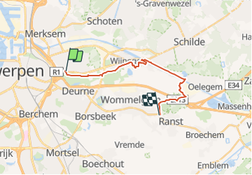

Length
15.6 km

Max alt
23 m

Uphill gradient
98 m
Km-Effort
16.8 km

Min alt
1 m

Downhill gradient
93 m
Boucle
No
Creation date :
2021-09-26 09:58:03.0
Updated on :
2021-09-26 09:58:05.103
3h48
Difficulty : Medium

FREE GPS app for hiking
 SityTrail
IGN / Geographical institutes
SityTrail Plus
The world is yours!
About
Trail Walking of 15.6 km to be discovered at Flanders, Antwerp, Antwerp. This trail is proposed by ADL339.
Positioning
Country:
Belgium
Region :
Flanders
Department/Province :
Antwerp
Municipality :
Antwerp
Location:
Deurne
Start:(Dec)
Start:(UTM)
601963 ; 5675344 (31U) N.
Comments