


Hanches la croix pater de poigny

topophil
User
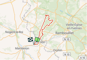

Length
39 km

Max alt
191 m

Uphill gradient
437 m
Km-Effort
44 km

Min alt
109 m

Downhill gradient
437 m
Boucle
Yes
Creation date :
2021-09-26 07:11:10.535
Updated on :
2021-09-26 10:32:12.765
2h47
Difficulty : Very difficult

FREE GPS app for hiking
 SityTrail
IGN / Geographical institutes
SityTrail Plus
The world is yours!
About
Trail Mountain bike of 39 km to be discovered at Centre-Loire Valley, Eure-et-Loir, Hanches. This trail is proposed by topophil.
Positioning
Country:
France
Region :
Centre-Loire Valley
Department/Province :
Eure-et-Loir
Municipality :
Hanches
Location:
Unknown
Start:(Dec)
Start:(UTM)
400100 ; 5383825 (31U) N.
Comments