


balade S-O

godmer
User
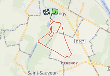

Length
7.2 km

Max alt
88 m

Uphill gradient
88 m
Km-Effort
8.3 km

Min alt
43 m

Downhill gradient
87 m
Boucle
Yes
Creation date :
2021-09-26 11:56:24.747
Updated on :
2021-09-26 11:56:20.873
1h53
Difficulty : Medium

FREE GPS app for hiking
 SityTrail
IGN / Geographical institutes
SityTrail Plus
The world is yours!
About
Trail Walking of 7.2 km to be discovered at Ile-de-France, Seine-et-Marne, Pringy. This trail is proposed by godmer.
Positioning
Country:
France
Region :
Ile-de-France
Department/Province :
Seine-et-Marne
Municipality :
Pringy
Location:
Unknown
Start:(Dec)
Start:(UTM)
467052 ; 5374150 (31U) N.
Comments