


boucle Valjoly

Lychee
User
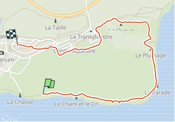

Length
2.3 km

Max alt
224 m

Uphill gradient
52 m
Km-Effort
2.9 km

Min alt
175 m

Downhill gradient
23 m
Boucle
No
Creation date :
2021-09-26 12:36:40.048
Updated on :
2021-09-26 13:23:22.024
37m
Difficulty : Easy

FREE GPS app for hiking
 SityTrail
IGN / Geographical institutes
SityTrail Plus
The world is yours!
About
Trail Walking of 2.3 km to be discovered at Hauts-de-France, Nord, Eppe-Sauvage. This trail is proposed by Lychee.
Positioning
Country:
France
Region :
Hauts-de-France
Department/Province :
Nord
Municipality :
Eppe-Sauvage
Location:
Unknown
Start:(Dec)
Start:(UTM)
581361 ; 5552257 (31U) N.
Comments