


Lamentin

sameja
User
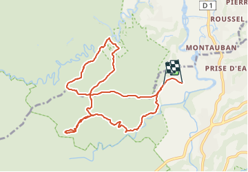

Length
14.2 km

Max alt
275 m

Uphill gradient
457 m
Km-Effort
20 km

Min alt
97 m

Downhill gradient
481 m
Boucle
No
Creation date :
2021-09-26 11:05:45.0
Updated on :
2021-09-26 13:57:02.346
2h50
Difficulty : Difficult

FREE GPS app for hiking
 SityTrail
IGN / Geographical institutes
SityTrail Plus
The world is yours!
About
Trail Trail of 14.2 km to be discovered at Guadeloupe, Unknown, Petit-Bourg. This trail is proposed by sameja.
Description
Forêt de celus
Positioning
Country:
France
Region :
Guadeloupe
Department/Province :
Unknown
Municipality :
Petit-Bourg
Location:
Unknown
Start:(Dec)
Start:(UTM)
642586 ; 1791981 (20Q) N.
Comments