


Rando du 26/09/2021. A-R Giens

dudu79
User
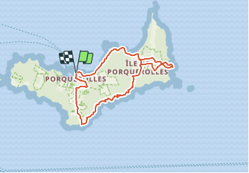

Length
15.4 km

Max alt
126 m

Uphill gradient
372 m
Km-Effort
20 km

Min alt
0 m

Downhill gradient
371 m
Boucle
Yes
Creation date :
2021-09-26 17:03:06.255
Updated on :
2021-09-26 17:03:08.952
4h37
Difficulty : Medium

FREE GPS app for hiking
 SityTrail
IGN / Geographical institutes
SityTrail Plus
The world is yours!
About
Trail Walking of 15.4 km to be discovered at Provence-Alpes-Côte d'Azur, Var, Hyères. This trail is proposed by dudu79.
Description
Rando sur l'île de Porquerolles
Positioning
Country:
France
Region :
Provence-Alpes-Côte d'Azur
Department/Province :
Var
Municipality :
Hyères
Location:
Unknown
Start:(Dec)
Start:(UTM)
272007 ; 4764861 (32T) N.
Comments