


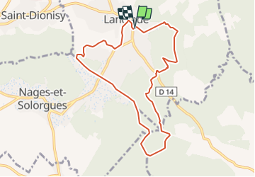
LANGLADE SUD

rando30129
User

Length
9.3 km

Max alt
145 m

Uphill gradient
167 m
Km-Effort
11.6 km

Min alt
61 m

Downhill gradient
170 m
Boucle
Yes
Creation date :
2021-09-26 17:25:40.811
Updated on :
2021-09-26 17:36:04.206
2h59
Difficulty : Difficult

FREE GPS app for hiking
 SityTrail
IGN / Geographical institutes
SityTrail Plus
The world is yours!
About
Trail Walking of 9.3 km to be discovered at Occitania, Gard, Langlade. This trail is proposed by rando30129.
Positioning
Country:
France
Region :
Occitania
Department/Province :
Gard
Municipality :
Langlade
Location:
Unknown
Start:(Dec)
Start:(UTM)
600773 ; 4850727 (31T) N.
Comments