


Modette Caraque

sameja
User

Length
21 km

Max alt
122 m

Uphill gradient
438 m
Km-Effort
26 km

Min alt
20 m

Downhill gradient
444 m
Boucle
No
Creation date :
2021-09-27 10:57:41.0
Updated on :
2021-09-27 13:46:42.967
2h46
Difficulty : Medium

FREE GPS app for hiking
 SityTrail
IGN / Geographical institutes
SityTrail Plus
The world is yours!
About
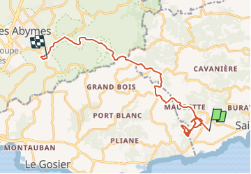
Trail Walking of 21 km to be discovered at Guadeloupe, Unknown, Sainte-Anne. This trail is proposed by sameja.
Description
Saint Anne Abymes
Photos


Positioning
Country:
France
Region :
Guadeloupe
Department/Province :
Unknown
Municipality :
Sainte-Anne
Location:
Unknown
Start:(Dec)
Start:(UTM)
669592 ; 1794261 (20Q) N.
Comments