


2021 Brevant

Airelle
User
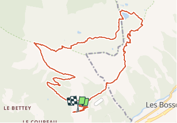

Length
15.4 km

Max alt
2289 m

Uphill gradient
1135 m
Km-Effort
31 km

Min alt
1352 m

Downhill gradient
1113 m
Boucle
Yes
Creation date :
2021-09-27 07:17:51.0
Updated on :
2021-10-07 17:16:42.968
6h50
Difficulty : Very difficult

FREE GPS app for hiking
 SityTrail
IGN / Geographical institutes
SityTrail Plus
The world is yours!
About
Trail Walking of 15.4 km to be discovered at Auvergne-Rhône-Alpes, Upper Savoy, Les Houches. This trail is proposed by Airelle.
Positioning
Country:
France
Region :
Auvergne-Rhône-Alpes
Department/Province :
Upper Savoy
Municipality :
Les Houches
Location:
Unknown
Start:(Dec)
Start:(UTM)
330275 ; 5085886 (32T) N.
Comments