


z Tourrettes 28-09-21

cb8310
User
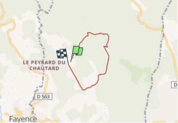

Length
4.7 km

Max alt
418 m

Uphill gradient
51 m
Km-Effort
5.3 km

Min alt
383 m

Downhill gradient
47 m
Boucle
Yes
Creation date :
2021-09-28 08:16:22.919
Updated on :
2021-09-30 02:32:21.914
1h33
Difficulty : Very easy

FREE GPS app for hiking
 SityTrail
IGN / Geographical institutes
SityTrail Plus
The world is yours!
About
Trail Walking of 4.7 km to be discovered at Provence-Alpes-Côte d'Azur, Var, Tourrettes. This trail is proposed by cb8310.
Description
rando très facile en sous-bois bien ombragé
Photos

Positioning
Country:
France
Region :
Provence-Alpes-Côte d'Azur
Department/Province :
Var
Municipality :
Tourrettes
Location:
Unknown
Start:(Dec)
Start:(UTM)
315412 ; 4834248 (32T) N.
Comments