


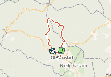
oberhaslach

jean charles daniel.
User

Length
10.4 km

Max alt
669 m

Uphill gradient
509 m
Km-Effort
17.1 km

Min alt
270 m

Downhill gradient
510 m
Boucle
Yes
Creation date :
2021-09-28 07:17:06.682
Updated on :
2021-09-28 12:50:41.025
3h39
Difficulty : Difficult

FREE GPS app for hiking
 SityTrail
IGN / Geographical institutes
SityTrail Plus
The world is yours!
About
Trail Walking of 10.4 km to be discovered at Grand Est, Bas-Rhin, Oberhaslach. This trail is proposed by jean charles daniel..
Photos

Positioning
Country:
France
Region :
Grand Est
Department/Province :
Bas-Rhin
Municipality :
Oberhaslach
Location:
Unknown
Start:(Dec)
Start:(UTM)
376294 ; 5378854 (32U) N.
Comments