


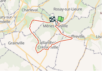
20210928 Menesqueville

Childebert
User

Length
12.8 km

Max alt
131 m

Uphill gradient
178 m
Km-Effort
15.2 km

Min alt
44 m

Downhill gradient
175 m
Boucle
Yes
Creation date :
2021-09-28 12:01:03.572
Updated on :
2021-09-28 15:29:44.229
3h28
Difficulty : Easy

FREE GPS app for hiking
 SityTrail
IGN / Geographical institutes
SityTrail Plus
The world is yours!
About
Trail Walking of 12.8 km to be discovered at Normandy, Eure, Ménesqueville. This trail is proposed by Childebert.
Positioning
Country:
France
Region :
Normandy
Department/Province :
Eure
Municipality :
Ménesqueville
Location:
Unknown
Start:(Dec)
Start:(UTM)
385010 ; 5468663 (31U) N.
Comments